Fire Insurance Plans are an invaluable resource when researching the history of a property and its neighbourhood. They provide a visual history of an area and many professionals, such as environmental consultants and historians, use Fire Insurance Plans on a regular basis to determine past land use.
Fire Insurance Plans are detailed large-scale maps of cities, smaller municipalities, public facilities and industrial sites. The object of these plans is to show the character of any insured building. These plans were compiled by the Fire Insurance Underwriters to assist their agents in assessing and controlling the risks of fire. Various symbols and colours are used to indicate features on the plans including: the shape and size of a building; the type of construction used; underground storage tanks; the existence of fire protection facilities; and the use of the building (e.g., restaurant, service station, dry cleaner, etc.).
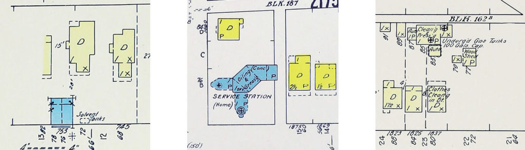
The plans were first drawn using a scale of 50 feet to the inch (relative scale 1:600). Later, this scale was increased to 100 feet to the inch (1:1 200), especially in residential areas, and finally 200 feet to the inch (1:2400).
Follow this link to discover more about the history of Fire Insurance Plans
Fire Insurance Plans are available for over 1000 cities and towns in all ten Canadian provinces and the Yukon Territory; they are also available for towns that no longer exist, such as Tranquille, Phoenix, Fort Steele and Fraser Mills, British Columbia.
Many cities have multiple plans (different years), such as the City of Vancouver and for some downtown locations, there are over 10 different Fire Insurance Plan years available, dating from the 1880s to the 1960s. Because of my experience, I can find Fire Insurance Plans quickly.
After contacting me with the site address I will advise how many Plans (i.e. 1893, 1913, 1928, 1942, 1955, etc.) are available for your site. Once I know how many Plans are required, I will send a quote. Once, the quote is accepted, I will send the plans via email (usually same day). The plans are high resolution digital colour reproductions in JPEG format (Assuming originals are in colour, which most are).
Fee Structure…
The research fee is $50.00 for the first sheet, then $20.00 for each additional sheet. There are bulk discounts on the entire order when requesting over 5 sheets (10% off), over 10 sheets (15% off), over 15 sheets (20% off) and over 20 sheets (25% off). GST is applicable to the above fees.
If your site is not covered on Fire Insurance Plans, a $25 research fee applies.
Payments can be made by cheque, PayPal (credit card) or internet e-transfer.
Fire Insurance Plans are for research purposes ONLY.
The fees are for my research and distribution services only. Payment does not entitle ownership of a Fire Insurance Plan.
My research includes, but is not limited to, the following sources:
– Vancouver Archives
– University of British Columbia Special Collections
– Vancouver Public Library Special Collections
– New Westminster Public Library
– North Vancouver Archives
– West Vancouver Archives
– Victoria Archives
– BC Archives
Below is an excerpt from a July 1893 Fire Insurance Plan of Vancouver. (click image for high res version)
The white coloured areas are where the Fire Insurance Plan was updated in 1901.
As you can see, the detail is excellent and the plan is very easy to read.
